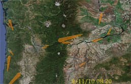
Real-time NW wind display courtesy of BPA
The public can now view a new online display of wind and other data the Bonneville Power Administration (BPA) uses to monitor weather conditions that drive the growing amount of wind energy generated in the Northwest.
The display is available at bpa.gov/go/windsocks and requires Java Runtime 5.0.
BPA installed the 14 weather stations last year to help improve forecasts of wind and the energy it generates so BPA and wind energy producers better anticipate power flows through the Northwest electric grid. The weather stations stretch from the Coast to eastern Oregon and Washington and include Astoria’s Megler Bridge; Mary’s Peak, the highest point in Oregon’s Coast Range; and Sunnyside, west of Richland, Wash.
The online display animates the windsocks in five-minute increments over the preceding three hours. The windsocks often swing around and grow as storm fronts sweep into the region, driving higher winds that generate more energy. The new display combined with BPA’s real-time chart of energy generation provides a look at the relationship between Northwest weather and wind energy.
The weather stations also provide temperature, barometric pressure and humidity data, which are visible by hovering your mouse over each station on the animated map.


